


Project NOAH
Description de Project NOAH
Project NOAH for Android
Enabling the mobility of Project NOAH. The official mobile version (native Android) of Project NOAH website (noah.dost.gov.ph) though without the Flood Map features.
This mobile app was developed by Rolly Rulete in cooperation with Project NOAH and with the partnership of Smart Communications, Inc. through the Smart Developer Network (SMART DevNet). Content and data come from the Department of Science and Technology (DOST) and its participating agencies.
Project NOAH’s (Nationwide Operational Assessment of Hazards) mission is to undertake disaster science research and development, advance the use of cutting edge technologies and recommend innovative information services in government's disaster prevention and mitigation efforts. Though the use of science and technology and in partnership with the academe and other stakeholders, the DOST through Program NOAH is taking a multi-disciplinary approach in developing systems, tools, and other technologies that could be operationalized by government to help prevent and mitigate disasters.
FEATURES:
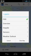
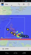
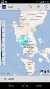
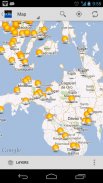
1. Map View
- PAR (Philippine Area of Responsibility)
- Overview (MTSAT, Rainfall Contours, Chance of Rain, etc)
- Doppler (Subic, Tagaytay, Cebu, Hinatuan, Tampakan)
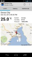
- Sensors (Weather Stations, Stream Gauges, Rain Gauges, Tide Levels)
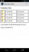
- Weather Outlook (Probablity of Rain, PAGASA Typhoon Forecast)
2. List View
- Almost the same with Map View but presented as list for ease of use.
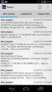
3. News
- DOST-PAGASA
- ClimateX
- PAGASA-FFWS (Flood Forecasting and Warning Section)
4. Help
- Help articles and guidelines
5. Info
- Information Dashboard
- Useful links and contents
* plus status notifications for "Probability of Rain"
* share screenshot (in almost all views) or text contents (News) via applications (Facebook, Twitter, Instagram, Bluetooth, Gmail, etc)
* the app is themeable! (Holo Light [default theme] OR Holo Dark)
* supports animated overlays (MTSAT, Doppler, Chance of Rain)
* improved caching for performance and offline usage
* very flexible Settings
keywords: DOST, PAGASA, NOAH, NDRRMC, nababaha, ClimateX, MMDA, SMART, SMART DevNet
</div> <div jsname="WJz9Hc" style="display:none">Projet NOAH pour Android
Activation de la mobilité du projet NOAH. La version officielle mobile (Android native) du site du projet NOAH (noah.dost.gov.ph) mais sans la Carte inondations fonctionnalités.
Cette application mobile a été développée par Rulete Rolly en collaboration avec le projet NOAH et en partenariat avec Smart Communications, Inc. à travers le réseau de développeurs intelligente (SMART DevNet). Contenu et les données proviennent du ministère de la Science et de la Technologie (DOST) et ses organismes participants.
(Nationwide Operational évaluation des risques) La mission du projet NOAH est d'entreprendre des recherches en sciences de la catastrophe et le développement, promouvoir l'utilisation de technologies de pointe et de recommander les services d'information innovants dans la prévention des catastrophes du gouvernement et les efforts d'atténuation. Bien que l'utilisation de la science et de la technologie, et en partenariat avec le milieu universitaire et d'autres intervenants, le DOST le cadre du Programme NOAH adopte une approche multi-disciplinaire dans le développement de systèmes, des outils et d'autres technologies qui pourraient être opérationnalisée par le gouvernement pour aider à prévenir et atténuer les catastrophes .
CARACTÉRISTIQUES:
1. Carte Voir
- PAR (Zone Philippine de responsabilité)
- Vue d'ensemble (MTSAT, les précipitations Contours, Chance of Rain, etc)
- Doppler (Subic, Tagaytay, Cebu, Hinatuan, Tampakan)
- Capteurs (stations météo, fluviomètres, pluviomètres, les niveaux de marée)
- Perspectives météo (probablity de pluie, PAGASA Typhoon Prévision)
2. Liste
- Presque la même chose avec la carte Consultez mais présenté sous forme de liste pour la facilité d'utilisation.
3. Nouvelles
- DOST-PAGASA
- CLIMATEX
- PAGASA-FFW (la prévision des crues et la section d'alerte)
4. Aide
- Articles d'aide et de directives
5. Infos
- Tableau de bord de l'Information
- Liens utiles et des contenus
* Les notifications d'état ainsi que pour "Probabilité de pluie"
* Le contenu (Nouvelles) part d'écran (dans presque tous les points de vue) ou le texte via des applications (Facebook, Twitter, Instagram, Bluetooth, Gmail, etc)
* L'application est themeable! (Holo Light [thème par défaut] OR Holo foncé)
* Prise en charge des superpositions d'animation (MTSAT, Doppler, Chance of Rain)
* Amélioration de la mise en cache des performances et l'utilisation hors ligne
* Les réglages très souples
Mots-clés: Dost PAGASA, NOAH, NDRRMC, nababaha, CLIMATEX, MMDA, SMART, SMART DevNet</div> <div class="show-more-end">
Project NOAH - Version 1.2.8
(09-12-2018)Project NOAH - Information APK
Version APK: 1.2.8Package: ph.gov.dost.noah.androidAncienne Version de Project NOAH
Autres versions


Applications de même catégorie

Vous pourriez également aimer...


